News Info News

This news article was originally written in Spanish. It has been automatically translated for your convenience. Reasonable efforts have been made to provide an accurate translation, however, no automated translation is perfect nor is it intended to replace a human translator. The original article in Spanish can be viewed at GIM Geomatics dota la cueva de Altamira de documentación 3D para la conservación preventiva de su arte rupestre
The scanner 3D of high speed Lighthouse Focus3D has been the tool used like solution that has allowed to achieve a break-even point between conservation and diffusion

GIM Geomatics Endows the cave of Altamira of documentation 3D for the preventive conservation of his rupestrian art
Editorial Interempresas08/04/2014
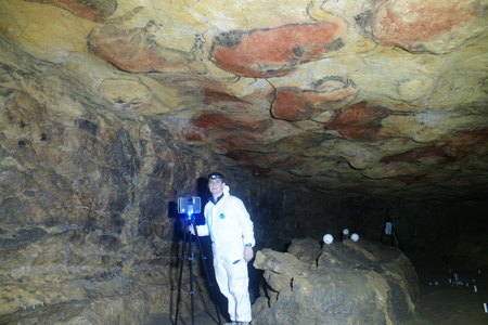
At present, the known cave finds closed and subjected to strict environingingmental controls because of his state of conservation
Cuevas of Altamira

Cuevas of Altamira.

GIM Geomatics, company devoted to the Management of Information of the Civil Heritage, Industrial, Historical and of the Environingingment, of the hand of Lighthouse, has endowed to the cave of Altamira of a documentation 3D reliable of high resolution, that allowed to tackle the preventive conservation of the cave and his rupestrian art by means of the employment of the new technologies, with a low environingingmental impact and big empleabilidad by part of researchers, restorers and agents to take decisions on her. For this, has used the scanner Lighthouse Focus3D, of frequent use in the rehabilitation of buildings by his high provision.

At present, the cave of Altamira finds closed and subjected to strict environingingmental controls because of his state of conservation. The cave has problems of maintenance derived of his fragile structure, of the works of conditioning realizar in his interior –that have modified his fitness and consistently the behaviour of the environingingmental parameters- and of the effect caused by the massive visit of the public during several decades.

Until the intervention of GIM Geomatics, lacked a topography of high precision that integrated the information of the outside of the cave and his geological structure as, for example, the location and relation with the outside of the points of infiltration of water and dripping in contact with the paintings, zones with biodeterioro, etc. or, in the operative management – delimitation of zones of maximum protection, of control of chemical and biological contributions from the external subsoil and limit of vibrations-.

The cave of Altamira was included in 1985 in the List of the World-wide Heritage by the Unesco. It locates in Santillana of the Sea, in Cantabria (north of Spain). It contains an important yacimiento archaeologic and is known universally by the importance and transcendence of his rupestrian Art paleolithic.
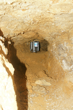
Scanner in the cave

Scanner in the cave.

Nowadays, the tools for the preventive conservation and the operative management are clearly old-fashioned or are clearly insufficient for the knowledge and control of his conservation. A newer exit that the cartographic documentation consists in the creation of virtual models, allowing the tourist exploitation of said resources, and avoiding the deterioration.

At present, by means of the integration of different tools geomáticas 3D, is possible to realizar a fast register, of precision and reliable of complex elements like caves or cavities. Said information can be employed to derive cartography, such as flat in plant, curves of level, longitudinal and transversal sections, three-dimensional analyses like calculation of heights of galleries or monteras and climatic simulations. All this documentation can serve like base by the agents of the same to help to the taking of decisions and establish methodologies for predictive calculations inside a system based in the knowledge.

Because of the operative rapidity of field, the accuracy of the data, the possibilities of representation and the inocuidad, the Lighthouse Focus3D could consider like the optimum tool for the conservation and diffusion of this valuable historical heritage.
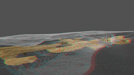
Resulted

Resulted.

The Laser Scanner Focus3D of Lighthouse uses technology laser to generate three-dimensional images of geometries and complex surroundings in so alone some minutes with a level of incredible detail. Also, it is efficient, fast and precise, economic and of big simplicity in his utilisation. His tactile screen for his control is so simple to handle like a digital camera.

“Come using technology Lighthouse of scan from the Lighthouse LS880 –affirms Vicente Bayarri, general director of GIM Geomatics -. For this project decide us by the Focus3D because, in addition to the exposed, by his size and ergonomics, fundamental in surroundings so irregular and narrow, the Focus3D creates a virtual and precise copy of the reality with an accuracy milimétrica, to an incredible speed of until 976.000 points of measurement by second. Besides the altímetro and the compass facilitate the use and automatic register”.

“The degree of satisfaction has been maximum —continues Bayarri—. Besides, of his improved ergonomics regarding the previous models, has us allow to access to places narrower and complexes to register because of his reduced dimensions, by what has improved noticeably the percentage of final information captured of all the cave”.

Comments on article / news piece

#1 - cesar garcia, de venezuela
10/12/2019 0:44:21
quería saber el costo del escáner faro focus 3D?

New comment

Warning

Los comentarios son la opinión de los usuarios y no la del portal. No se admiten comentarios insultantes, racistas o contrarios a las leyes vigentes. No se publicarán comentarios que no tengan relación con la noticia/artículo, o que no cumplan con el Aviso legal y la Política de Protección de Datos.

Advertencias Legales e Información básica sobre Protección de Datos Personales:
Responsable del Tratamiento de sus datos Personales: Interempresas Media, S.L.U. Finalidades: Gestionar el contacto con Ud. Conservación: Conservaremos sus datos mientras dure la relación con Ud., seguidamente se guardarán, debidamente bloqueados. Derechos: Puede ejercer los derechos de acceso, rectificación, supresión y portabilidad y los de limitación u oposición al tratamiento, y contactar con el DPD por medio de lopd@interempresas.net. Si considera que el tratamiento no se ajusta a la normativa vigente, puede presentar una reclamación ante la AEPD.

Suscríbase a nuestra Newsletter - Ver ejemplo

Password

Select all

Autorizo el envío de newsletters y avisos informativos personalizados de interempresas.net

I authorize the sending of communications from third parties via interempresas.net

He leído y acepto el Legal notice y la Data protection policy

Responsable: Interempresas Media, S.L.U. Purpose: Subscription to our newsletter(s). User account management. Sending emails related to the same or related to similar or associated interests.Retention: for the duration of the relationship with you, or as long as necessary to carry out the specified purposesTransfer: Data may be transferred to other group companies for internal management purposes.Rights: Access, rectification, opposition, deletion, portability, limitation of processing and automated decisions: contact our DPD. If you consider that the processing does not comply with the regulations in force, you may lodge a complaint with the AEPD.More information: Data protection policy

REVISTAS

TOP PRODUCTS

NEWSLETTERS

  • Newsletter Urbanismo y Medio ambiente

    05/09/2024

  • Newsletter Urbanismo y Medio ambiente

    04/07/2024

Latest news

Featured companies

OPINIÓN

ENTIDADES COLABORADORAS

OTRAS SECCIONES

Services