Los instrumentos topográficos como alternativa en la medición industrial
De esta forma, dos ciencias como la topografía-geodesia y la metrología, aparentemente dispares, se acercan para poder solucionar problemas geométricos. En cualquier caso no debe olvidarse que la metrología moderna surge en el siglo XIX junto a la geodesia, y que la primera definición del metro se obtiene a partir de las medidas geodésicas del arco del meridiano, medido entre otros por los españoles Jorge Juan y Antonio de Ulloa.
El general Ibáñez de Ibero fundador y primer director del Instituto Geográfico fue el primer presidente del Comité Internacional de Pesas y Medidas, lo que explica el camino recorrido en compañía por ambas ciencias en España, hasta no hace mucho años.
Instrumentos topográficos en la industria
En topografía obtener incertidumbres de medida inferiores al centímetro requiere metodologías específicas, sin embargo en metrología 0,1 mm suele ser una precisión exageradamente alta. Las mayores contribuciones a dicha incertidumbre en trabajos topográficos convencionales son las asociadas al error que se comete al realizar la puntería sobre el objeto y al error debido a situar el instrumento sobre un punto determinado. En topografía industrial se minimiza el primer aspecto utilizando placas de puntería muy precisas adaptadas a las cortas distancias y se solventa el segundo drásticamente, no estacionando el instrumento sobre un punto prefijado.
En topografía clásica de campo, son dos los trabajos tipo que pueden realizarse: el levantamiento o llevarnos al papel (ordenador) el terreno y el replanteo o marcar en el terreno los elementos de un proyecto del que se dispone en el ordenador. En topografía industrial la determinación tridimensional de un objeto equivaldría al levantamiento y el montaje al replanteo.
En cuanto a los accesorios, algunos típicamente metrológicos se adaptan a estos instrumentos para permitir su uso industrial. Micrómetros de placas plano paralelas, oculares de autocolimación, pentaprismas, dianas, espejos, oculares acodados, espejos autonivelantes, objetivos de autorreflexión, etc., permiten que estos instrumentos diseñados para su utilización en las ciencias geográficas, se adapten a fines industriales.
Niveles ópticos
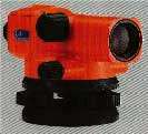
Habitualmente disponen de micrómetros de placas plano paralelas que permiten leer a reglas graduadas con resoluciones de 10 µm.
Los niveles más modernos sustituyen el ojo humano por cámaras CCD y las reglas graduadas convencionales por otras de "código de barras", de forma que se evalúa la altura interceptada mediante una correlación entre la imagen obtenida y un código de referencia. Estos instrumentos sacrifican precisión, pero permiten la automatización en la toma de datos. Son ampliamente utilizados en el control de deformaciones de las centrales nucleares.
Lógicamente tanto la horizontalidad del eje óptico del instrumento como la graduación de las reglas utilizadas deben ser convenientemente calibrados.

Teodolitos
En diversas aplicaciones industriales van provistos de un ocular de autocolimación, utilizándose para la determinación de planitud y rectitud, la alineación de ejes de giro de maquinaria, la calibración de mesas giratorias o la medida de los ángulos formados por las caras de un satélite.
La utilización de dos teodolitos convenientemente orientados constituye un método alternativo a las tradicionales máquinas de medición por coordenadas.
La exactitud de este método de intersección óptica depende, además del tipo de teodolito utilizado, de la geometría de la medida, de la estabilidad del objeto a medir y de los teodolitos y de las condiciones ambientales. Pueden alcanzarse precisiones del orden de 10-5 de la dimensión medida.
Las ventajas principales de este método de no contacto de medida 3D es poder desplazar los equipos a la sala donde se sitúe la pieza a medir y permitir la medida de piezas de cualquier dimensión. Sin embargo, por tratarse de un método de una cierta complejidad con tiempos de medición largos, puede afectar a la estabilidad del sistema y por tanto a su exactitud.
Algunas aplicaciones del método de intersección espacial mediante teodolitos son el control de robots, en la industria naval, espacial y de automoción, aunque ha dejado paso en muchas de sus aplicaciones a los sistemas de seguimiento láser.
Taquímetros
Estos sistemas, al igual que el método anterior, van asociados a software metrológico, lo que les permite incrementar su versatilidad.
Una evolución de este sistema, mejorando su exactitud en gran medida, son los sistemas de seguimiento por láser. Los medidores dinámicos polares solucionan la falta de exactitud de los taquímetros en la medida de distancias, incorporando un interferómetro láser. Como éste no proporciona distancias absolutas, algunos sistemas incorporan además medidores de distancias similares a los de uso topográfico, pero de resolución metrológica (1 µm). Por otro lado, mantienen el dinamismo y la versatilidad. Los laser trackers eliminan el aspecto óptico de los instrumentos topográficos incorporando un sistema de seguimiento del reflector.
Este sistema, va implantándose en la Industria poco a poco, aunque su alto precio impide una utilización mayor.
Fotogrametría
La obtención de las coordenadas 3D de un punto se obtienen mediante la intersección de las rectas definidas por las coordenadas del punto principal de cada cámara y de las fotocoordenadas de la imagen del punto a determinar. La utilización de modernas cámaras métricas digitales facilita el proceso. La precisión de este método puede alcanzar hasta 10 µmm, dependiendo de la distancia del objeto a las cámaras y de la geometría de la intersección
Referencias
- Santos Mora, Antonio. Aplicaciones industriales de la topografía, COITT. Madrid 1998.
- Fdez. Pareja, Teresa; Bisbal, Javier. Aseguramiento de la calidad en topografía. Control metrológico de instrumental topográfico, Topcart 2000.
- Prieto, Emilio; Bisbal, Javier. La calidad y la instrumentación topográfica, Congreso Galego da Calidade (2001).
Necesidad de calibración
Se ha puesto de manifiesto la amplia aplicabilidad de los instrumentos topográficos en distintos sectores de la Industria. Pero no sólo debe tenerse presente el fin de medición del sistema, sino que debe contemplarse las necesidades de calibración que ello conlleva. Por ello en el Área de Longitud del Centro Español de Metrología se ha habilitado un Laboratorio de Instrumentos Topográficos destinado a dar este servicio.
En aquellos casos donde aún no se dispone de suficiente información sobre los procedimientos de calibración más adecuados, se están desarrollando los estudios pertinentes, como por ejemplo, con los sistemas de seguimiento láser.

